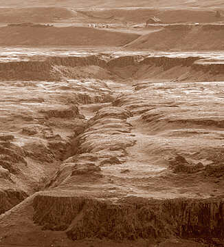
The river bluffs. [note farm in background]
Courtesy of Jay Cousins, photographer.
The landscape of the Pacific Northwest is a combination of mountains and deserts. On the west coast, the Cascade Mountains run the length of the North American continent parallel to the Pacific Ocean. The east side of the Pacific Northwest is framed by the Rocky Mountains and the Umatilla Mountains. Between these three mountain ranges is the great inland desert of the Pacific Northwest.
The great inland desert, or the Columbia Plateau as it is sometimes called, is a bleak landscape covered in bunch grass. There are few trees to be seen and little surface water. The inland desert is covered by the volcanic ash of ancient Cascade Mountain eruptions.1 In many places in the Columbia River Plateau the topsoil, created by volcanic ash, is over 100 feet thick.
Current scientific thought believes the Plateau to have been sculpted by floods. Ancient glaciers, which dammed rivers in the high Rockies, melted and flooded across most of Eastern Washington and Oregon. A series of floods is believed to have occuried repeatedly during the last ice age. The floods, known collectively as the Great Missoula Floods, cut deep coulees across the plateau.2 In many places 2,500 feet of basalt was cut by the flood waters. This erosion created a landscape of steep flat topped hills surrounded by cliffs of basalt rock. The cliffs and gorges left by the receding flood waters created a difficult landscape for settlers.
The earliest settlers of the Columbia River Plateau area "lived in rockshelters near the confluence of the Palouse and Snake rivers" between 9,000 and 11,000 years ago.3 By the 1800's the area along the Snake River was considered a part of the Nez Perce tribal homelands. One of the earliest routes through this rough terrain was the Nez Perce trail.
The first white settlers in what became known as Garfield county, came in 1858 after years of Indian unrest in the area. The settlement of the interior Pacific Northwest, or the Palouse, was particularly slow and difficult.4 Most of the coastline of the Pacific Northwest had settlements by the first half of the 1800's. After the rich grasslands of the Walla Walla area were settled pioneers began to turn their attention to the lands bordered by the Spokane River on the north, and the Umatilla Mountains in the south and east.
Garfield county located in the southern area of what is now Washington state, is boardered on the north by the Snake River. Following earlier game trails settlers traveled from Walla Walla to Dayton, in the north east, and continuing in a north easterly direction into the Garfield area. Most early settlers established farms in the canyon bottoms and along the creek beds. They tended to stay close to the main road leading to Dayton and Walla Walla, these being the chief supply points in the region. As more of what was to become Garfield county became settled, the homes, farms and ranches retreated further away from the main roads.
Settling further from main roads meant traveling greater distances to purchase supplies. The sheer physical difficulties of traveling or hauling produce, grain, or supplies to or from market was major concern of these settlers. The rugged landscape was the chief obstacle of the farmers of the Palouse.
1. Ficken, Robert E., Charles P. LeWarne. Washington A Centennial History, (University of Washington Press, Seattle, 1989). 4.
2. A complete description of the prehistoric Lake Missoula floods may be found in Keith Petersen's River of Life, Channel of Death, 25-34.
3. Petersen, Keith C. River of Life, Channel of Death: Fish and Dams on the Lower Snake, (Lewiston, ID: Confluence Press, 1995). 35.
4. This region within Washington state is known by several names: the Inland Empire, the Palouse, and the Columbia River Plateau.
Introduction
Geography
• Farming
• Transportation
• Grain Chutes
• Mayview Tramway
Bulk Handling
• Conclusion
• Bibliography
• Oral Interviews
• Maps
• Illustrations
Acknowledgements
• Comments
![]()